 |
|
|
|
|
Stop by the Canoe Country Book Store for a many selections of book titles about the BWCA, Quetico and canoe camping, including Boundary Waters and Quetico Guide Books QueticoPark.com recommends WA Fisher Maps for the Boundary Waters and Quetico Park. Only Fisher Maps are accurate enough to be used for finding portages, hiking trails and campsites. |
|
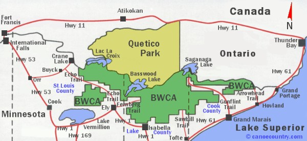
Quetico Provincial Park Reservations line 1-888-668-7275 Entry Point Map
You may need a Remote Border Crossing Permit to enter the Quetico Park
|
| French
Lake - Dawson Trail Northern Region Accessible from HWY 11 |
#11.
Baptism Creek #12. Pickerel Lake |
|
Quetico Park Headquarters
/ Atikokan Entry Northern Region Located in Atikokan at 108 Saturn Ave. |
#21.
Batchewaung Lake #22. Sue Falls #23. Mack Lake |
| Beaverhouse
Lake Northern Region Accessible from HWY 11 |
#31.
Cirrus Lake #32. Quetico Lake |
| Lac
La Croix Western Region Accessible by paddle or tow from outfitter |
#41.
Threemile Lake #42. Maligne River #43. McAree Lake #44. Bottle River |
| Prairie
Portage - Basswood Lake Southern Region Accessible by paddle or tow from outfitter |
#51.
Basswood River #52. Sarah Lake #53. Kahshahapiwi Lake #61. Agnes Lake #62. Carp Lake |
| Cache
Bay Southeastern Region Accessible by paddle, tow from outfitter or fly-in permit #75 |
#71.
Knife Lake #72. Man Chain Lakes #73. Falls Chain Lakes #74. Boundary Point, Saganagons Lake #75. Cache Bay Fly-In |
|
For general assistance with canoe trip planning, canoe entry points, permits, regulations and route information from the most experienced canoe outfitters Click Here for a quick response. For information about cabins and lodging Click Here for a quick response. |
|
Order
Maps Here |
|